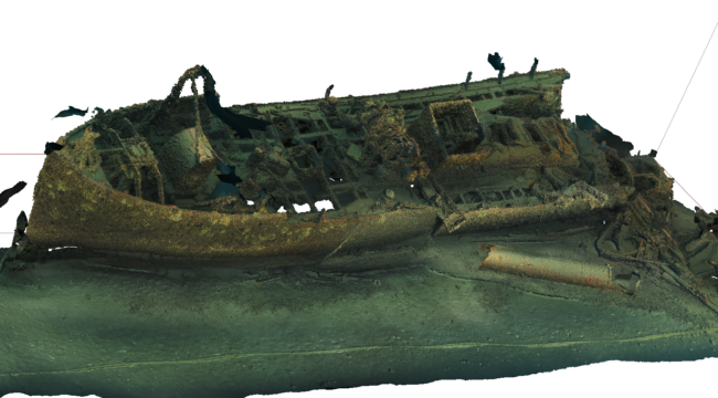
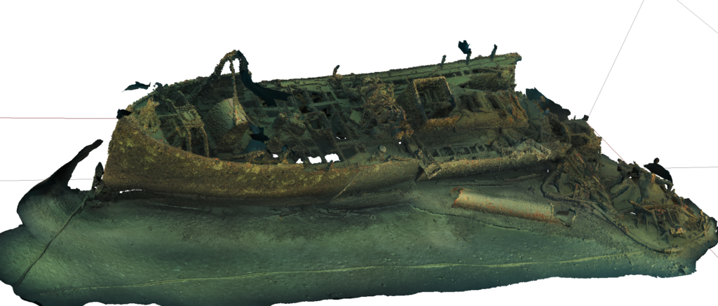
The Donator wreck (Port-Cros national Park, Hyères)
The Donator (or Prosper Schiaffino) is a former banana and wine cargo ship that sank by a mine on November 10th, 1945. Today it is one of the most famous wrecks in the Mediterranean Sea. It is home to a luxuriant fauna that makes its reputation among divers.
The survey of the Donator (-50 m) covers a length of approximately 100 m and a width of approximately 15 m. For the realisation of the model, the data acquisition was carried out with the Karkam system. Image processing and 3D modelling were carried out with Metashape. About 60,000 images were taken. The results are presented in the form of 3D point clouds and a 3D mesh, both with millimetre precision. The realisation of the 3D model of this wreck allowed us to determine a methodology adapted to the 3D survey of complex objects (architectural complexity, elevation) with the problematic of diving in an open environment (diving in open water) and at this depth. We have adapted our diving procedures (planning and choice of rescue methods, coupling the photo survey with the movement of the divers via the use of scooters).
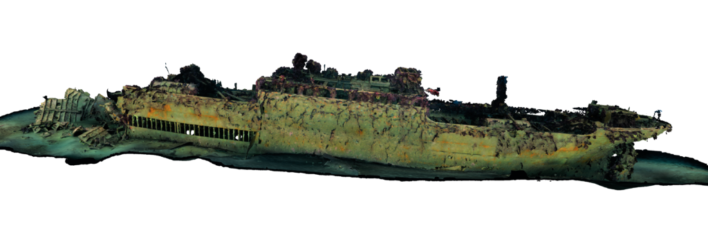
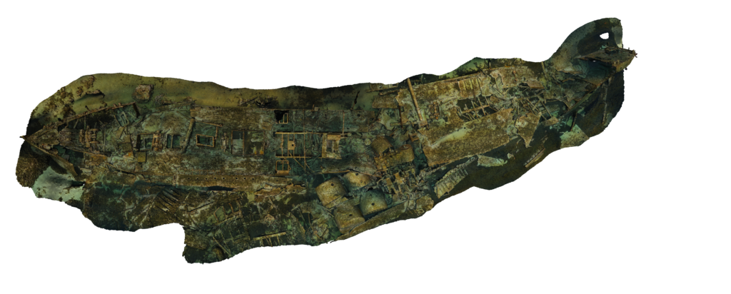
The Arroyo wreck (Cape Sicié, Six-Fours-les-Plages)
The Arroyo was a French Navy tanker designed to supply other ships in water. This 680-ton, 55 m long ship served from 1921 to 1953, when it was sunk near the rocks of the two brothers near Cap Sicié by the GERS to serve as a training site for the French Navy.
This wreck lies today at 36 metres depth. It broke into two parts on a rock near the bow. The wreck rises to a depth of approximately 20 metres.
The survey of the Arroyo (-36 m) covers a length of approximately 70 m and a width of approximately 20 m. Data acquisition was carried out with the Karkam system. Image processing and 3D modelling were carried out with Metashape. About 30,000 images were taken. The results are presented in the form of 3D point clouds and a 3D mesh, both with millimetre precision. The realisation of the model of this wreck allowed us to determine a methodology adapted to the 3D survey of complex objects (architectural complexity,
The high resolution 3D point cloud is available here
The Ker-Bihan wreck (Marseilles)
The Ker-Bihan was a 33 m long steam trawler. In 1914, in the middle of World War I, it was requisitioned and transformed into a minesweeper. On January 23rd, 1918, the ship was blasted by a mine laid in the bay of Marseille by the German submarine U.C. 67, a minesweeper. The explosion pulverised its stern, 14 victims were registered. It should be noted that the Ker-Bihan sank on the same day as the Drôme, which was only a few yards away in 55 m of water.
The survey of the Ker-Bihan (-60 m) covers a length of 33 m for a width of about 10 m. The depth of the wreck (-60 m) required the use of rebreathers (CCR) to access it by diving. Data acquisition was carried out in 10 dives with a Nikon D700 and two external flashes. Image processing and 3D modelling were carried out with Metashape. Approximately 8000 images were taken. Image processing and 3D reconstruction were carried out on a dedicated machine over a total period of 7 days. The results are presented in the form of 3D point clouds and a 3D mesh, both with millimetric precision. This made it possible to archive the state of the wreck at a given time (in May-June 2020) and thus to monitor the evolution of its colonisation by fixed fauna over time.
The Le Liban wreck (Calanques national Park, Marseilles)
The Le Liban was a 91 m long liner which sank on June 7th, 1903 south of the Ile Maïre at the eastern entrance to the bay of Marseilles, taking with it around 100 victims. it sank following a collision with another ship, while on its way to Corsica. Resting at a depth of between 28 metres and 35 metres, this wreck is now the subject of numerous recreational dives. It is currently the subject of the National research programme “Save Our Shipwreck”, jointly run by the CEA, the CNRS, the University of Pau and the Pays de l’Adour, the DRASSM and the company A-CORROS, which aims to establish a methodology for safeguarding metal wrecks along the French coast.
The Liban wreck survey (-35 m) covers a length of 92 m and a width of approximately 10 m. Data acquisition was carried out in 10 dives with a D700 and two external strobes. Image processing and 3D modelling were carried out with Metashape. The results are presented in the form of 3D point clouds and a 3D mesh, both with millimetric precision. The realisation of the model of this wreck allowed us to determine a methodology adapted to the 3D survey of objects covering a large surface. This wreck is located near a site that we modelled in its entirety: the Pharillons.
About 18,000 images were taken. The image processing and 3D reconstruction were carried out on a dedicated machine over a total period of 7 days. The results are presented in the form of 3D point clouds and a 3D mesh, both with millimetric precision. This made it possible to archive the state of the wreck at a given time (in May-June 2020), which will make it possible to monitor the evolution of its colonisation by fixed fauna over time. The construction of this shipwreck model enabled us to determine a methodology adapted to the 3D survey of complex objects (architectural complexity, elevation) with the problem of diving in an open environment (diving in open water) and at this depth. We have adapted our diving procedures (planning and choice of rescue methods, coupling the photo survey with the movement of the divers via the use of scooters).
The high resolution 3D point cloud is available ici
The Messerschmitt Bf 109 Wreck (Calanques national Park, Marseilles)
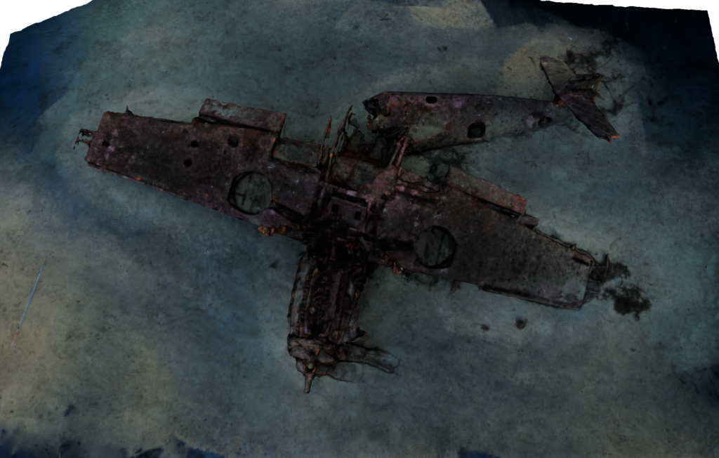
The wreck of the Messerchmitt (-45 m depth) sank in 1944 near the Planier islet. This detailed model was used as a reference to define the shooting parameters necessary for the accuracy of our models in 2016. The photogrammetry of this wreck is the result of a collaboration between the LIS (Laboratoire d’Informatique des Systèmes, UMR CNRS 7020) and Septentrion Environnement.
The high resolution 3D point cloud is available here.
Monitoring of the archeological excavation of the Anemone (LES SAINTES, GUADELOUPE)
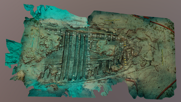
The site of the wreck identified today as the Anemone was located in 1990 by C. Edouard. After a DRASSM expertise in 2002, an archaeological survey in 2015 and then an annual programmed excavation in 2016, helped to relocate the wreck and to provide convincing elements for the identification of the site (artillery, archaeological furniture, shipbuilding characteristics). These initial operations confirmed archival research on the presence and sinking of the Anemone, a schooner belonging to the Royal Navy in Guadeloupe and the Saintes during the winter of 1824. Built in Bayonne in 1823, the Anemone was used during the Spanish Civil War and then sent to the West Indies to serve as an estate ship. It was armed with two 12-gauge carronades of the 1818 type, with a crew of about thirty men under the command of Louis Guillotin. In Guadeloupe, it participated in various missions, including the control of the coast and the fight against the illegal slave trade, which had been prohibited in theory since 1817.
Photogrammetry was used to follow the evolution of the archaeological site of the Anemone, a 19th century schooner. The photogrammetric coverage was carried out in 2017, 2018 and 2019 by O. Bianchimani and Pierre Drap with the survey of the test pits and their progressive calibration. Finally, the last phase of sampling of the wreck’s structures enabled the xylological study to be finalised. In order to follow the evolution of the excavation from a qualitative and quantitative point of view, four surveys were organised, which served both to archive the different states of the wreck during the excavation, to evaluate the changes of the site over time and to support the archaeological analysis. All the records are expressed in the same reference system and scaled independently. The scaling and permanence of the datum was obtained by comparing the size of the quadrat bars (2.944 m) with the surveyed dimensions. Depending on the extent of the surveyed areas, the accuracy varied from 1 mm to 1 cm. In addition, scaling control test patterns were placed on each survey.
The high resolution 3D point cloud is available here