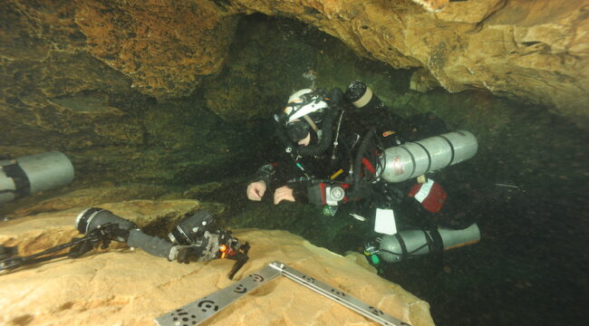
Boulegeade Cave
The survey of the Boulegeade cave (-25 m) covers a developed length of 35 m for a width ranging from 2 to 5 m and a height ranging from 2 to 4 m, representing approximately 800 m². This survey combines several 3D reconstructions carried out at different scales, allowing a landscape view of the cave but also the detailed study of interesting areas. The 3D reconstruction used for the landscape views of the cave is of millimetric precision and offers a high definition texture allowing a very detailed virtual visit of the site. A single scaled photogrammetric model (and therefore a single set of photographs) was used to produce the 3D reconstructions at different scales and resolutions. The choice of this approach was guided by the need to avoid any contact with the substrate and therefore the impossibility of depositing acoustic station-type sensors, but also in order to limit the time spent on site. Data acquisition (photogrammetric photography) was carried out in 4 hours on site using a Nikon D700 camera integrated into a Nauticam housing and equipped with two SB800 strobes. Approximately 6000 images were taken. Image processing and 3D reconstruction were carried out on a dedicated machine (dual Xeon processor, 512GB memory) for a total duration of 8 days. The results are presented in the form of 3D point clouds and a 3D mesh, both with millimetric precision, as well as a photographic corpus. In addition to the overall 3D reconstruction of the cave, areas of interest were also surveyed with sub-millimetric precision. This allowed the scientists to use both photographic documents and a three-dimensional reconstruction covering the same areas with great precision.
3D model export of Boulegeade Cave (Marseilles, Calanques national Park)
Goul du Pont Cave
The collaboration between CNRS-LIS and Septentrion Environnement has made it possible to obtain a 3D model of the Goul du Pont cave, located in Bourg-Saint-Andéol in Ardèche (07, France). The “Goul du Pont” is a famous underwater cave for technical scuba diving, whose exploration began in the mid 1950s. The underwater photogrammetric survey was very difficult due to the morphology of the cave and covered the sections described below. The entrance is located at -12 m, along a cobble slope. An oval-shaped, almost horizontal tunnel leads to the first chamber at a distance of 75 m from the entrance and at a depth of -18 m. The path becomes almost vertical until -33 m, followed by a succession of vertical steps until -60 m (125 m from the entrance). Here the section reduces and, with a more gradual slope, the tunnel reaches a depth of -79 m at 157 m from the entrance. At this point, the dimensions of the section decrease further to approximately 1.2 x 2 m. The photogrammetric survey was carried out by Olivier Bianchimani and his team with a digital SLR camera (Nikon D700) equipped with a 14 mm Nikkor lens, mounted in a Nauticam waterproof housing. To maximise image coverage in such a narrow space, the image acquisition followed a helical path. 4,452 images were collected and processed in a semi-automatic pipeline. In the most critical and narrowest sections, automatic feature extraction and matching algorithms failed; therefore, attachment points were manually identified to connect and orient the different parts together. Scale bars with circular coded targets provided the scale for the photogrammetric model and allowed connection between the underwater survey with the aerial survey.
3D model export of Goul du Pont Cave (Ardèche, France)